

A Winter Sunrise in the Himalayas
It’s 6.50 in the morning. My room is a cosy 21+ centigrade, but I have dressed up in a down jacket and snow boots to protect myself from the bone chilling -15 degrees centigrade weather waiting for me outside. I intend to capture the breath-taking vistas at sunrise from the roof top of my hotel in Leh town. Sunrise would be at 7:15 AM and I am hoping to see a riot of colours in the sky.
Since we are so high up, the sunrise is usually not very colourful. Yet we were fortunate to witness jaw-dropping twilight colours on the mountains that cold morning. In the picture the orange light is only visible towards the left side of the mountain ranges, leaving the right side into deep shadows, creating a 3D illusion in the picture. That’s the magic of winter in Ladakh!
Leh is a town in the Leh district of the Indian state of Jammu and Kashmir. Leh district has an area of 45,110 sq km. Leh, the capital of the district, is a high, desert city, known for its Buddhist sites.

God beams at Dudhwa National Park
This shot captures the sunrays in a dense forest just after sunrise on a winter morning.
I am at Dudhwa in Uttar Pradesh, India. During the winter months, these intense ‘God beams,’ as they are nicknamed, are only visible for less than an hour between 7:30 AM and 8:30 AM when the morning fog envelopes the forest. When the God beams penetrate the thick canopy of trees, the fog quickly dissipates and the God beams vanish. So we were rushing to catch this magical phenomenon in this 45 minutes’ window. And we were blessed to witness exactly what we wanted to capture.
I have travelled to many forests in Northern India, Southern India and Central India, For me, possibly, this is one of the most beautiful forests I have visited in India. This National Park has an unparalleled symmetry of endless straight tunnel-like roads with an overhead canopy of trees along the way. These sal trees were planted by the British to be used for laying railway tracks and all the roads are connected like a star network with 5-road junctions throughout the forest. This is unique to this National Park.
The Dudhwa National Park is in the Terai region of Uttar Pradesh, India, and covers an area of 490.3 sq km (189.3 sq mi). It is part of the Dudhwa Tiger Reserve. Located on the Indo-Nepal border in Lakhimpur-Kheri district in Uttar Pradesh, together with Dudhwa National Park and Kishanpur Wildlife Sanctuaries, the area represents the best natural forests and grasslands left in the Terai region of Uttar Pradesh.
The park has a sizable number of tigers and leopards, although the thick vegetation makes it difficult to spot one

Colours of a Fisherman
Umngot River, Meghalaya’s Unexplored Paradise!
A paradise nestling in the hills… if ever there was one!
I ventured off the beaten track to discover a little known gem, Umngot, possibly India’s cleanest river. The Umngot river flows through Dawki, a small but busy town in the East Jaintia Hills district near the Indo-Bangladesh border. The river is a prime fishing spot for fishermen from nearby areas.
I am waiting for the sun to drop down behind the mountains so I can avoid the glare or reflections of the water in my photograph. Are you wondering how I captured this aerial shot from my DSLR? Here is the secret! I was standing on a 6-foot high hanging (and very shaky, literally) iron rope bridge, as I waited for the perfect composition. I was overwhelmed by the colours in this single object, the boat. It seemed like a staged filmy photo. We can see the fisherman completely dressed in blue, the pink bag, a red tub, a brown basket with a net, a yellow cover, a silvery white fish lying on the floor of the boat, a blue-green mug, a fishing stick with bluish green rope and, finally, red life jackets. All of them are adding to the drama of the picture, suspended against a monochromatic teal background.
The water is so clear that when seen from a distance, it appears as if the boat is floating in mid-air!

Frozen streams in the Himalayas
Far from civilisation, in a region without any electricity, flows this mountain stream, seen here in various stages of ice formation — the inner, slate grey watery spirals and the frosty white edges bordering the dry brown grass.
It’s a cloudy day on a winter afternoon. The temperature is -15 Centigrade and we have spent several hours waiting for some exciting natural light effects to warm up the landscape. The image was looking very flat in the absence of dynamic light. At last, our patience was rewarded. The clouds opened up a little for us and I could capture the dynamic light on a section of the snowy mountains that gave depth to the picture. For a photographer, light is everything.
In the foreground you can see the frozen stream in various stages of ice formation — the inner, slate grey watery spirals and the frosty white edges bordering the dry brown grass.
This photo was taken at Ladakh in Jammu & Kashmir state, India.

Milkyway Reflections over Mt Nun and Kun in Himalayas
The pristine beauty of the night sky can best be admired in the absence of light pollution. Here is the Milky Way reflection over streams in the Himalayas.
It was the month of June in Suru valley. The Galactic Centre or the Milky Way is visible in these areas from around 9:30 AM until 3:30 AM. The intensity and clarity of the Milky Way is so stunning up here that it is really hard for a layman to believe. But I have had the good fortune to witness it.
If you look at a dark sight finder or a light pollution map you will see that there is no light pollution in a major part of the Himalayas. In this region, there is no electricity in a 500 sq km area. A few solar lights function for two hours every day.
This picture was exposed for 15 seconds at F/2.8 and 6,400 ISO to capture these perfect details in the sky. It was close to a New Moon day.
With the naked eye, you can see the Milky Way with less intensity than visible in this picture. It appears like a rainbow — rising in the south and setting in the north.
The Nun Kun mountains are a pair of Himalayan peaks: Nun, 7,135 m (23,409 ft) and its neighboring peak Kun, 7,077 m (23,218 ft). Nun is the highest peak in the Himalayan range on the Indian side of the Line of Control in Jammu and Kashmir. There are higher peaks in the Indian side of the Karakoram range, the highest is in the Zanskar range in Ladakh. These twin mountains, Nun and Kun, are near the Suru valley, about 250 km (160 mi) east of Srinagar.

Wandering Mist in Arunachal Pradesh
Early morning mist wandering over the paradise village in Sangti valley in the Lower Himalayas at 5:40 AM!
Paradise valley is not well known to the outside world. In fact, very minimal tourist infrastructure exists here. But, in my mind, this is the place to go to if you are seeking rest and relaxation in a heavenly hill station. Surrounded by the towering ranges of the Eastern Himalayas, blessed by pleasant weather round the year, with maybe some light snowfall in the winter months, dotted with pristine forests and meandering fast hill rivers.
Sangti Valley is on the Bomdila – Tawang highway of Western Arunachal Pradesh in North East India.

Twilight Reflections of Mt Nun and Kun
Sunset reflections in quiet side streams below Mt Nun and Kun in the Himalayas, close to Zanskar region.
We were on a 9-day trip to Zanskar region in the Himalayas. And this was the most beautiful sunset we witnessed on the trip. The skies glowed a pinkish red for a few minutes and it was a visual feast to see these hues reflected on the clouds and above the peaks of Mt Nun and Kun.
The Nun Kun mountains are a pair of Himalayan peaks: Nun, 7,135 m (23,409 ft) and its neighboring peak Kun, 7,077 m (23,218 ft). Nun is the highest peak in the Himalayan range on the Indian side of the Line of Control in Jammu and Kashmir. There are higher peaks in the Indian side of the Karakoram range, the highest is in the Zanskar range in Ladakh. These twin mountains, Nun and Kun, are near the Suru valley, about 250 km (160 mi) east of Srinagar.
The Nun Kun mountain massif dominates the skyline in the upper Suru valley. The two peaks are separated by a snowy plateau of about 4 km in length. Pinnacle Peak (6930m) is the third highest mountain in this group.

Infinite Canopy at Dudhwa
In the Dudhwa forest on a winter morning, the canopy of trees reaching up to the sky is so dense that the sun rays struggle to break through them to touch the earth. Now and then, the tree tops allow a sliver of light to slip in.
This picture shows the true mood of the forest in shadows during early mornings and late evenings. If you look closely you can see a small streak of light on a tree trunk on the far left side.
I have travelled to many forests in Northern India, Southern India and Central India, For me, possibly, this is one of the most beautiful forests I have visited in India. This National Park has an unparalleled symmetry of endless straight tunnel-like roads with an overhead canopy of trees along the way. These sal trees were planted by the British to be used for laying railway tracks and all the roads are connected like a star network with 5-road junctions throughout the forest. This is unique to this National Park.
The Dudhwa National Park is in the Terai region of Uttar Pradesh, India, and covers an area of 490.3 sq km (189.3 sq mi). It is part of the Dudhwa Tiger Reserve. Located on the Indo-Nepal border in Lakhimpur-Kheri district in Uttar Pradesh, together with Dudhwa National Park and Kishanpur Wildlife Sanctuaries, the area represents the best natural forests and grasslands left in the Terai region of Uttar Pradesh.
The park has a sizable number of tigers and leopards, although the thick vegetation makes it difficult to spot one.

Spectacular Twilight at Gokarna
Reflection of sunset over the sea scape.
We were here for 3 days to shoot sunsets at Gokarna beach. This evening presented us with the most spectacular sunset which lit up a fire in the sky. The myriad hues of yellow, pink and orange are reflected in the tranquil waters of the sea and light up the rocks in the foreground.
Gokarna is a town on the Arabian Sea, in the South Western Indian state of Karnataka. This small town boasts of several beautiful, unspoiled beaches such as palm-lined Gokarna in the center, as well as Kudle and Om beaches farther south.
Gokarna has become a favoured tourist destination over the years due to its vast stretches of picturesque sandy beaches. With a sizeable number of foreigners thronging here, it no longer remains a quaint temple town and has become a thriving vacation spot that is as laidback as Goa, but far less commercial. In fact, many Goa regulars have now moved on to Gokarna’s pristine beaches where the crowds are less.

Icy Formations at Lake Tso Moriri
On a cold winter morning we are up high in the Himalayas on the banks of Lake Tso Moriri in Ladakh, India. This is the highest lake in India.
We started at 4:00 AM in the morning from Changthang, on a mission to capture the twilight colours at Lake Tso Moriri. We had hoped to reach before 6:30 AM, but our car wheel got stuck in a one-foot ice sheet, which had formed on the road beside the lake. Our expedition team had to work hard to free the car from the ice sheet in -20 centigrade temperatures at that unearthly hour. Finally, we were free of the ice and resumed our journey.
All along the way, it was very cloudy. It seemed as if we would be caught up in a snow storm, not quite the ideal weather to see twilight colours. But nature had something else in store for us! Though we were very late in reaching the lake, the sky remained clear, surprising us! You never know what nature might offer you. We were able to capture stunning ice formations on the bank of the lake with the sun directly up in the sky, above them.
Lake Tso Moriri or "Mountain Lake" is a lake in the Ladakhi part of the Changthang Plateau in Jammu and Kashmir in Northern India. The lake is at an altitude of 4,522 m (14,836 ft). It is the largest of the high altitude lakes entirely within India and wholly within Ladakh in this Trans-Himalayan biogeographic region. It is about 16 miles (26 km) north to south in length and two to three miles (3 to 5 km) wide.
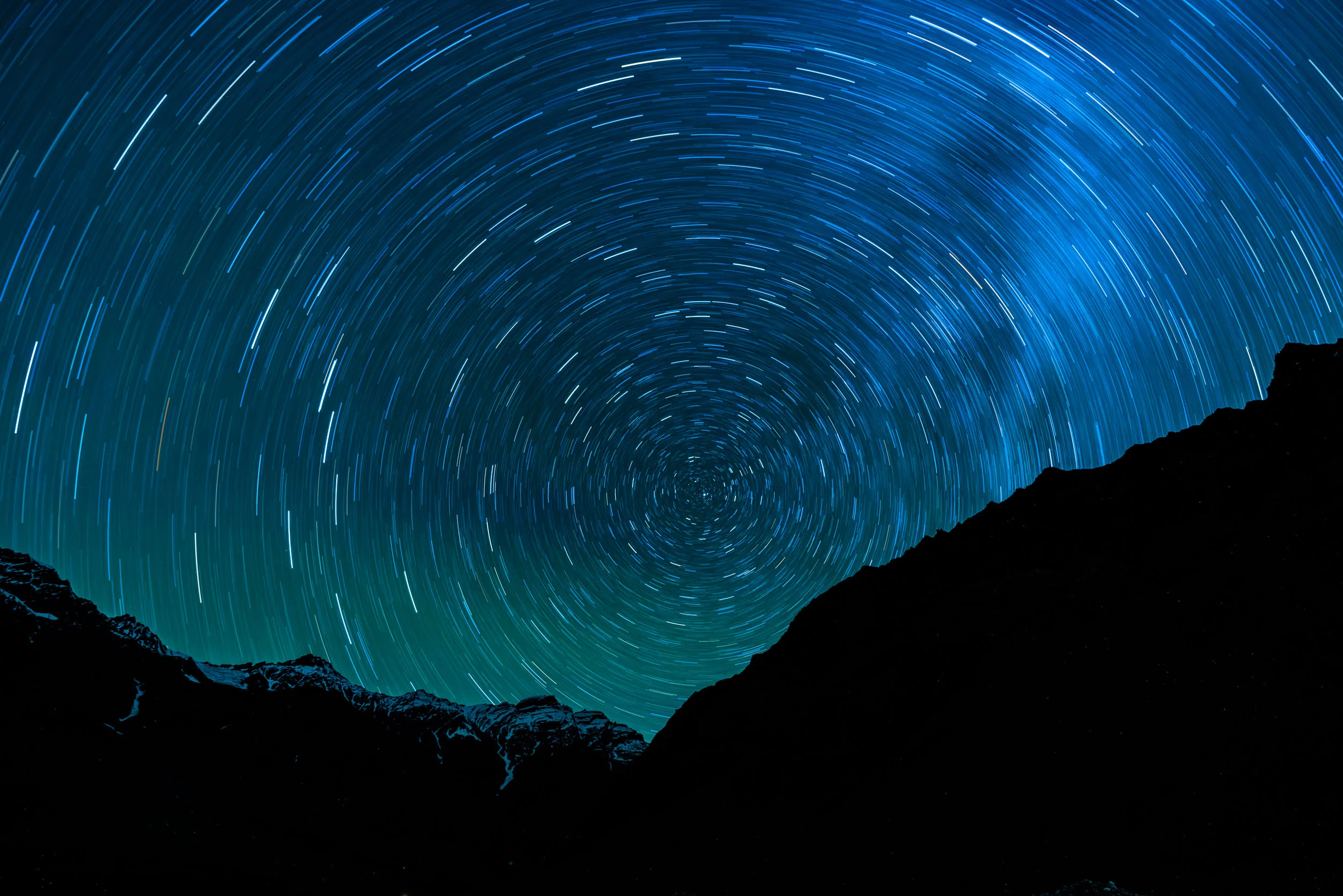
North Star Trails in the Sky
These glorious star trails around Polaris, the North Star. For the most common and often the most spectacular star trails.
The North Star or Pole Star – aka Polaris – is famous for holding nearly still in our sky while the entire northern sky moves around it. That’s because it’s located nearly at the north celestial pole, the point around which the entire northern sky turns. Polaris marks the way due north.
This shot was exposed for 32 Minutes to capture the star trails movement, Each line in the picture denotes single star movement in sky over 32 minutes duration.

Full Milkyway captured at Rangdum,Himalayas
Captured using RRS Multirow Panorama gear at Rangdum,Himalayas. Six pictures are stitched together to form fully Milky way pano picture.
Rangdum is in a valley situated 3,657 m (11,998 ft) above the sea level, in an isolated region of the Suru valley in the Ladakh region in the state of Jammu and Kashmir in Northern India. On one side are the colorful hills while on the other side are rocky mountains and glaciers.
Rangdum is located midway between Kargil and Padum. It is about 100 kilometers from Kargil. The road conditions are very bad near Rangdum. There is no access to electricity, phone or internet.

Frozen Panorama at Pangong Tso Lake
It may be one of the most challenging aspects of landscape photography to come out of a cosy warm sleeping bag and dress up in down jackets to face the -25 degrees Centigrade temperatures to capture a sunrise on the banks of Pangong Lake. Only a passion for landscape photography and the unwavering commitment to my quest for a perfect shot can motivate one to dare this weather. When I had to take off my glove to switch off the auto focus button on my camera to take this panoramic picture, in just 10 seconds I lost all sensation of touch. I could not switch it off myself and had to call my partner in adventure, Mr Naidu to do that job for me.
You can see the first rays of the sun falling on the mountains towards the extreme right, as it rises between the mountains on the left. The small ‘flashing mirror’ on the extreme right is our accommodation with plywood walls on three sides and a glass wall on the lake facing side. The frozen lake is in the foreground.
I was ecstatic to see these amazing sunrise colours in the sky after all our efforts. I collated a series of shots, stitching them up to make a panorama.
Pangong Tso is a Salt Lake in the Himalayas, situated at a height of about 4,350 m (14,270 ft) and the winter temperatures range from -10 to -30 degrees centigrade. It is the second highest lake in India.
Pangong Lake is 134 km (83 mi) long and extends from India to China. Approximately 60% of the lake lies in China. The lake is 5 km (3.1 mi) wide at its broadest point. All together it covers 604 sq km. During winters the lake freezes completely, despite it being saline water.

Green Vine Sanke
Green Vine Snake (Common Vine Snake) is the most widely distributed Ahaetulla species in India also the only species of genus in most of the parts of peninsular and northern India. One of the most common and ecologically significant species of Western Ghats. It can be identified easily by checking very thin & long body including tail, green dorsal, leaf or arrow like head with very pointed snout.
Suman Raju Porfolio Images
Wildlife Filmmaker & Cameraman